By Masiding Noor Yahya
“Deep in a cool ravine in the outskirts of a peaceful sleepy town in Lanao del Sur lie one of what probably is the oldest concrete bridge still standing in Mindanao and two majestic and bewildering natural scenes.”
Over ten years ago, I was invited to visit the municipality of Lumbaca Unayan in Lanao del Sur by its then municipal mayor Saripodin A. Guro for a short documentary coverage.
During the travel I brought with me my colleague, the late Frank Dosdos, and a professional photographer by the name of Jun Pacapac. It took us more than two hours of land travel from Iligan City to Lumbaca Unayan passing through the Islamic city of Marawi. Lumbaca Unayan used to be a part of the old town of Lumbatan, about 40 kilometers across the lake from Marawi.
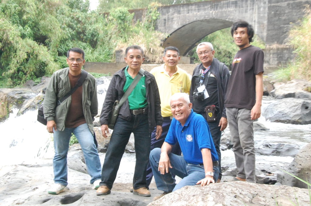
On board a Tamaraw FX that has probably survived quite many long summers, the group with five guides travelled last March 12, 2014, along the eastern length of the Lake Lanao Circumferential Road from Marawi to the towns of Ditsaan Ramain, Buadi Puso Buntong, Mulondo, Taraka, Poona Bayabao, Masiu, Tamparan, Lumbayanague and Lumbatan until we reached the vast plateau that is Lumbaca-Unayan.
We saw wide cornfields at various stages of maturity – some just weeks after planting, others just harvested while other strips of lands were left to fallow.
Young upland rice seemingly unharmed by the summer that has come to other parts of Mindanao was also growing on the deep sandy loam soil. The group was amazed by the richness of the soil and the potential it has for high-value vegetables and other crops.
Lumbaca-Unayan is a municipality with a population of 8,131 people, according to the 2020 Census, making it the least populated municipality in the province. It was created through the Muslim Mindanao Autonomy Act No. 106, signed by Nur Misuari on November 22, 2000, and a positive affirmation was given in a plebiscite on November 27, 2004.
After travelling for about 8 kilometers southward from the Poblacion, the vehicle began to head downward to a recently scraped portion of what looked like a provincial road that had wanted clearing for years. The grade was getting stiffer and dark clouds began to spread overhead casting a worrying probability of rain. Fearing that the vehicle will never be able to make a return uphill climb if it rains, the driver decided to stop. At this point, the group had to walk through the rest of the way.
Spread on the far left of the road, across a ravine, was an amazing panoramic view of forests and clouded mountain ranges. The guides told the group that the higher plateau on the far distant left is the municipality of Butig, believed to be the seat of the ancient Kingdom of Ranao that existed long before the Arab Muslim missionaries came.
Straight on the middle as far as the eyes can see were forests that led up to the tall mountain ranges in the east. It was learned that far down behind those mountains are plateaus facing Bukidnon and Maguindanao.
Bita River and the Old Bridge
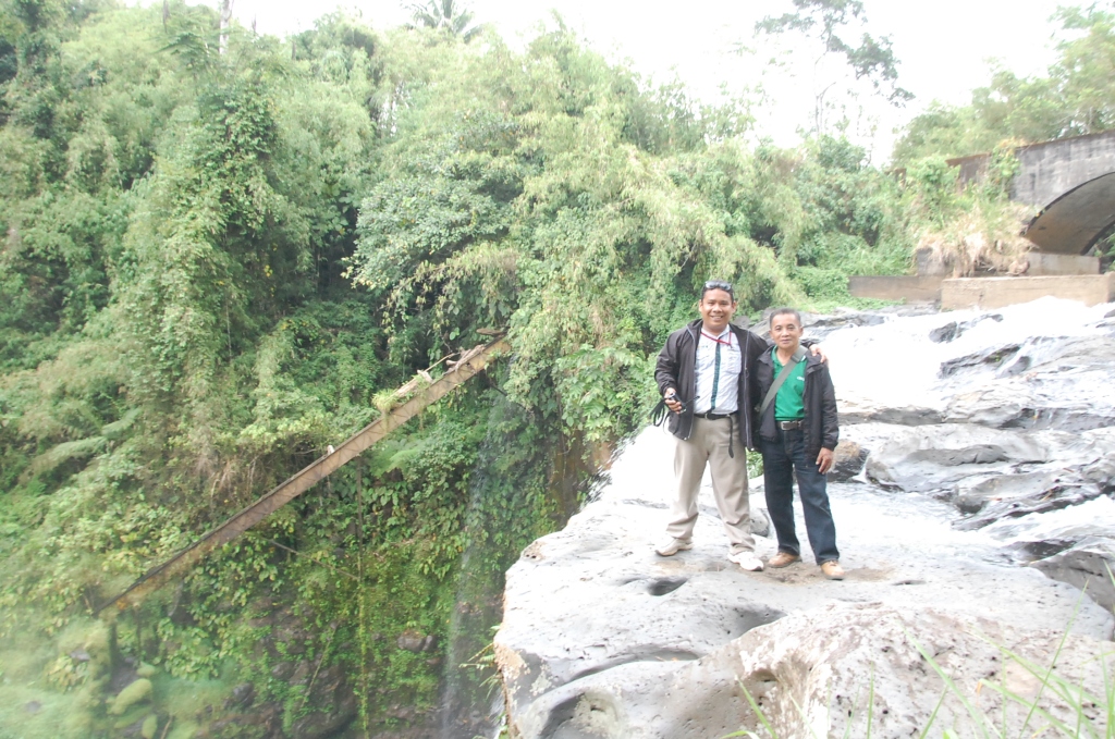
The road snaked down on curves and bends about five kilometers to the bottom of the ravine where the Bita River flows on the solid bed rock. It finally locked with the approach of an old concrete bridge crossing the river. The guides said that the bridge was called the “Old Spanish Bridge” by the Maranaos. But the inscription on the concrete side railing read, “1910 LT HD SHULTZ 21st Inf.”
It was said that perhaps, the bridge was started by the Spaniards and continued by the Americans. However, noting that the Spanish bridge construction technology when the Americans came used bricks, not concrete, the bridge as the inscriptions show was probably built by the U.S. Army. It was also learned that the bridge was never finished by its original builders due to persistent harassment by the Maranao defenders of the time. It was only recently, the guides told us, that the bridge was completed by the national government as a priority project of then Lanao del Sur 2nd District Representative Congressman Benasing O. Macarambon, Jr.
Kabobolodtowa Falls
Roughly fifteen meters downstream from the bridge, the river dropped about 40 feet below sending mists upward as the water bounce from the rocky floor. “Kabobolodtowa” is what the villagers call the waterfall, meaning ‘rainbow hub.’
It was said that when the bright sun shines, one would see rainbows in the mist – a phenomenon unseen in that overcast afternoon. But it was not the beauty of the falls but the potential it would give to the people of the adjoining areas that teases the imagination. It was gathered that there were plans to tap the waterfall for hydroelectric power generation.
Three hundred meters down the road ahead of the bridge, a small path to the right leads down to a shady lagoon about 50 feet down another gorge. The water comes from a hole bigger than enough to let a person come inside swimming underwater at the bottom of a rock wall.
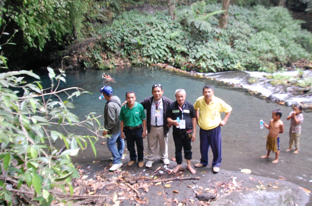
This shallow body of fresh water is said to be alkaline making the gravel and sand on the floor ever-clean. One can immerse in it and have a clean soap-less bath. Young children swam and frolic in the crystal-clear water where blades of light sift through the canopy of leaves in the thicket overhead.
Trekking the homeward uphill climb minutes later, the group had mixed feelings of wonder and exhaustion. Although we were very tired and worn when we reached the Poblacion of Lumbaca-Unayan at dusk, they had a feeling they will never forget. They hope that someday four-wheeled vehicles will be able to transport people who want to see the fascinating scenes they had beheld.
The road ahead of the bridge leads to the town of Marugong and comes into the municipality of Malabang. It is the alternate route from Lake Lanao to the national highway from Cotabato City to Pagadian and Zamboanga City.
After the provincial road from Lumbaca Unayan to Marugong and Malabang is concreted, the hidden beauties of nature in this midland river gorge will be seen by the rest of the outside world. The Bangsamoro Autonomous Region in Muslim Mindanao (BARMM) will pave the way to bring civilization to this somewhat forgotten nook in the globe.
Initially, BARMM through its interior and local government ministry which was then headed by Minister Naguib Sinarimbo had helped transformed the local government unit center from a sleepy wooden town hall to a lively multi-million concrete municipal hall building.
